The low water of Paraná River and its impact on the oil complex of Rosario Hub
PATRICIA BERGERO - JULIO CALZADA – CRISTIAN RUSSO – GUILLERMO WADE
The river's water level in the Port of Rosario's Hydrometer was 1.85 m, while its reference value is 2.47 m. The contractual commitment of the company Hidrovía SA, which is in charge of the dredging and beaconing of the navigable channel of the Paraná River, is to maintain depth of 10.36 m (34'00" feet deep). Given the current low water levels, at about two feet below the usual depth, ships will likely have to carry two feet less than the usual 10.36/10.51 m. This lower load, especially in the Rosario Hub, implies higher logistics and transportation costs that must be faced by industries, ports and operators of the area. It should be borne in mind that 78% of the national theoretical oilseeds processing capacity is located in the Rosario Hub. There are 29 port terminals located along the 70 km coastline that goes from Arroyo Seco to Timbúes, with its epicenter in the city of Rosario. 19 of these port terminals dispatch grains, oils and by-products, having 12 of them their own processing factories. In addition, there are 8 other oil factories in the area, totaling 20 industries that demand beans to produce oil and meal, among other variety of oil derivatives. Consequently, the exporting cluster of the Rosario Hub surpassed in 2016 all the others around the world, including the Customs District of New Orleans (USA) and the port node of Santos (Brazil). The remarkable current low water will affect this complex from the logistical point of view with a significant economic impact. What does the Port of Rosario's hydrometer show at present? What happened in the last 10 years?
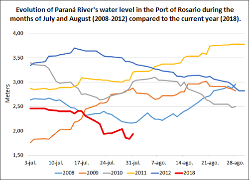 Historical data expose the severity of the current low while recent weeks' records evince that the water level of the Paraná River in the Port of Rosario is the lowest since 2008. On August 3, 2018 the measurement was 1.90 meters, exceeding by far the previous lowest record (2.37 meters) on the same date in 2008.
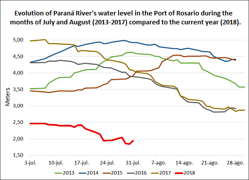 Thus, taking into account Paraná River's water levels over the last 5 years (2013-2018), it can be noted the severity of the current low. Over the period of 2013 to 2017 daily water levels during the month of July ranged from 3.4 to 5 meters, 2.3 m above this year's average value for July. What are the ships and the goods affected by the low water in the Rosario Hub? There were 61 vessels entering or loading/unloading in the Rosario Hub from July 18 to August 1, 2018 (two-week period). These vessels' cargoes loading/unloading operations are hampered by the low water of the river. There are 24 vessels trying to load or that have loaded about 782,000 tons of soybean meal, 21 ships to load 620 thousand tons of corn, 6 vessels to take about 158 thousand tons of soybean oil, 3 ships to load 86,800 tons of wheat; being these the most important cargoes. Other ships correspond to biodiesel, fuels, minerals, fertilizers, sunflower oil and meal, etc. These circumstances will continue to affect other vessels that enter/leave the port in the coming days.
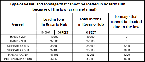 The chart above shows the loss of load in bulk carriers resulting from the lack of a 34 feet-deep draft due to the low. Larger ships lose loads of 3,200 to 4,300 tons. This leads to a "false freight" for the system or otherwise the need to complete the loading in places where there might not be any available merchandise or where its price might be higher than Rosario Hub's. There are numerous type of ships. Handysize and Handymax are the smallest ships that can carry up to 35,000 and 40,000 tons of deadweight. Normally, these vessels do not exceed a 34 feet draft because of their own design. Tanker big vessels are those that, if compared with bulk carriers, may resemble a supramax. Small tankers or small tanks are equivalent in size to the Handysize and Handymax. Supramax vessels are intermediate ships designed to carry 50,000 to 60,000 tons. Panamax, postpanamax and kamsarmax are all ships of similar size, with a capacity of 60/65 thousand tons to 90 thousand tons. For each sinking foot, these vessels earn approximately 2,000 / 2,500 tons of cargo. That is to say, that the 2 feet-deep reduction implies losing about 4,000 / 5,000 tons in each of these vessels. What is likely to occur with rains levels in Brazil? The opinion of Dr. José Luis Aiello According to Dr. José Luis Aiello, adviser of GEA - Strategic Guide for Agro/BCR, the decrease in the levels of Paraná River, and, specifically, in the Rosario Hub's area, was due to a lack of rainfall in Brazil since the installation of a high pressure center. This phenomenon is similar to the one that caused the severe drought that affected the Argentine countryside during 2017/2018 season. Dr. Aiello believes that "according to the forecasts, southern Brazil would receive adequate amounts of rain which would improve the situation (in terms of water flow) of the basin that includes the rivers of Paraná and Uruguay". The specialist, however, clarifies that temporary climate problems depend on dynamic atmospheric systems, which are not predictable in the medium term but are followed on a weekly scale. In other words, everything seems to indicate that it will start to rain in Brazil although there may be meteorological phenomena that could bring changes in this forecast. Rainfall in southern Brazil during the August-September-October period would be expected to improve the unfavourable situation at the Río de la Plata basin. However, we should consider that when it rains in southern Brazil the water would take approximately 30 days to reach our area. Furthermore, it should be bear in mind that in most dams the water level has also dropped. To produce energy, dams must maintain a constant flow of water, making energy generation much more expensive due to the low level. As a result, the first objective would be to return to the usual water level for dams and only when water reserve value is recovered will they send water to the rest of the system. For this reason, it is expected that the low water levels situation will prevail for some time in detriment of port operations. The vision of the Yacyretá Dam Binational Entity on Alto Paraná. In its report of July 30, the Yacyretá Dam Binational Entity reported that since the first quarter of 2018 rainfalls has been lower than the expected in the entire Paraná River basin upstream of Yacyretá Dam and adjacent areas. Flows throughout the river system are, therefore, below the historical average for this time of the year. For the June/July period, the current status is only comparable to what happened in 2001. For the long term, the National Meteorological Service's (AR) report foresees a "less than normal" situation for the Argentine portion of the Paraná River basin that contributes directly to Yacyretá Dam. According to this report, taking into account the seasonal climatic scenarios, the state of water reserves, and the fact that August is statistically a month of scarce rainfall in the region, it is not expected that the tendency of the river system would reverse in the short term.